
Thank you for supporting this site ❤️
Make a donation
Make a donation
Breadalbane topographic map
Click on the map to display elevation.
Thank you for supporting this site ❤️
Make a donation
Make a donation
About this map
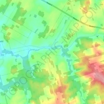
Name: Breadalbane topographic map, elevation, terrain.
Location: Breadalbane, Queens County, Prince Edward Island, Canada (46.33355 -63.54315 46.37531 -63.45718)
Average elevation: 68 m
Minimum elevation: 26 m
Maximum elevation: 140 m
Thank you for supporting this site ❤️
Make a donation
Make a donation
Other topographic maps
Click on a map to view its topography, its elevation and its terrain.