
Saint Saviour topographic map
Interactive map
Click on the map to display elevation.
About this map
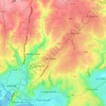
Name: Saint Saviour topographic map, elevation, terrain.
Location: Saint Saviour, Jersey (49.17630 -2.09939 49.22518 -2.04144)
Average elevation: 60 m
Minimum elevation: 0 m
Maximum elevation: 108 m
Other topographic maps
Click on a map to view its topography, its elevation and its terrain.
La Hougue des Geonnais (dolmen)
La Hougue des Geonnais (dolmen), Rue des Geonnais, Saint Ouen, JE3 2DL, Jersey
Average elevation: 45 m
Fort Regent
Fort Regent, La Chasse, St Helier, JE2 4UH, Jersey
Average elevation: 14 m