
Thank you for supporting this site ❤️
Make a donation
Make a donation
Dera Ismail Khan topographic map
Click on the map to display elevation.
Thank you for supporting this site ❤️
Make a donation
Make a donation
Dera Ismail Khan
D. I Khan is situated at an altitude of 177 metres above sea level.
Thank you for supporting this site ❤️
Make a donation
Make a donation
About this map
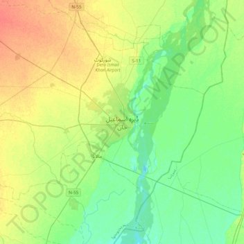
Name: Dera Ismail Khan topographic map, elevation, terrain.
Average elevation: 177 m
Minimum elevation: 162 m
Maximum elevation: 199 m
Thank you for supporting this site ❤️
Make a donation
Make a donation
Other topographic maps
Click on a map to view its topography, its elevation and its terrain.
Daraban Tehsil
Pakistan > Khyber Pakhtunkhwa > Dera Ismail Khan District
Daraban is a tehsil located in Dera Ismail Khan District, Khyber Pakhtunkhwa, Pakistan. It is located at 31°44'3N 70°20'11E and has an altitude of 221 metres (725 ft). Daraban is a small town which lies 40 miles (64 km) west of Dera Ismail khan in the foothills of Sulaiman Mountains. Daraban region has a…
Average elevation: 272 m