
Brisbane City topographic map
Interactive map
Click on the map to display elevation.
Brisbane City
Brisbane's topography is characterized by a series of hills and ranges that define its landscape. The city is situated on a low-lying floodplain, with the Brisbane River meandering through its heart, creating a winding course with many steep curves from the southwest to its mouth at Moreton Bay in the east. Elevations within the city include Mount Coot-tha, reaching up to 300 meters (984 feet), and other prominent rises such as Mount Gravatt, Toohey Mountain, Mount Petrie, Highgate Hill, Mount Ommaney, Stephens Mountain, and Whites Hill, which are dotted across the city. The D'Aguilar National Park, encompassing the D'Aguilar Range, bounds the north-west of Brisbane's built-up area and contains taller peaks like Mount Nebo, Camp Mountain, Mount Pleasant, Mount Glorious, Mount Samson, and Mount Mee. This varied terrain contributes to Brisbane's distinctive hilly landscape, with urban areas, including the central business district, partially elevated by spurs of the Herbert Taylor Range.
About this map
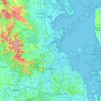
Name: Brisbane City topographic map, elevation, terrain.
Location: Brisbane City, Queensland, Australia (-27.66022 152.67969 -27.02201 153.46828)
Average elevation: 71 m
Minimum elevation: -3 m
Maximum elevation: 750 m
Other topographic maps
Click on a map to view its topography, its elevation and its terrain.