
Thank you for supporting this site ❤️
Make a donation
Make a donation
Albera Ligure topographic map
Click on the map to display elevation.
Thank you for supporting this site ❤️
Make a donation
Make a donation
About this map
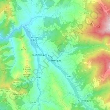
Name: Albera Ligure topographic map, elevation, terrain.
Location: Albera Ligure, Alessandria, Piedmont, Italy (44.68578 9.04624 44.72698 9.15668)
Average elevation: 641 m
Minimum elevation: 340 m
Maximum elevation: 1,359 m
Thank you for supporting this site ❤️
Make a donation
Make a donation
Other topographic maps
Click on a map to view its topography, its elevation and its terrain.
Thank you for supporting this site ❤️
Make a donation
Make a donation
Thank you for supporting this site ❤️
Make a donation
Make a donation