
Hunterdon County topographic map
Interactive map
Click on the map to display elevation.
Hunterdon County
Much of the county is hilly, with several hills rising to one thousand foot in elevation. The highest points are two areas in Lebanon Township, one on the Morris County line, both reaching approximately 1,060 feet (320 m) above sea level. The first is at Smith on the Morris County line and the second is north of the area called Little Brook. This area is known as the Highlands of New Jersey. The lowest elevation is where the Mercer County line reaches the Delaware River, approximately 50 feet (15 m) above sea level. The county is drained by the Musconetcong River in the north. The river flows in a southwest direction. The Lamington River drains the county in the east. The central portion of the county is drained by the South Branch of the Raritan River. The Delaware River drains the western side of the county.
About this map
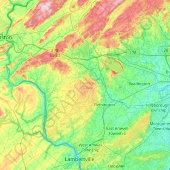
Name: Hunterdon County topographic map, elevation, terrain.
Location: Hunterdon County, New Jersey, United States (40.33943 -75.19549 40.78909 -74.70369)
Average elevation: 120 m
Minimum elevation: 10 m
Maximum elevation: 384 m