
Thank you for supporting this site ❤️
Make a donation
Make a donation
Phoenix topographic map
Click on the map to display elevation.
Thank you for supporting this site ❤️
Make a donation
Make a donation
About this map
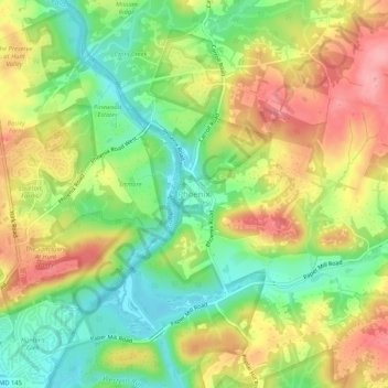
Name: Phoenix topographic map, elevation, terrain.
Location: Phoenix, Baltimore County, Maryland, 21030, United States (39.49639 -76.63778 39.53639 -76.59778)
Average elevation: 123 m
Minimum elevation: 71 m
Maximum elevation: 181 m
Thank you for supporting this site ❤️
Make a donation
Make a donation
Other topographic maps
Click on a map to view its topography, its elevation and its terrain.
Bowleys Quarters
United States > Maryland > Baltimore County > Bowleys Quarters
Average elevation: 2 m
Thank you for supporting this site ❤️
Make a donation
Make a donation
Soldiers Delight Natural Environment Area
United States > Maryland > Baltimore County > Owings Mills
Average elevation: 187 m
Thank you for supporting this site ❤️
Make a donation
Make a donation
Thank you for supporting this site ❤️
Make a donation
Make a donation