
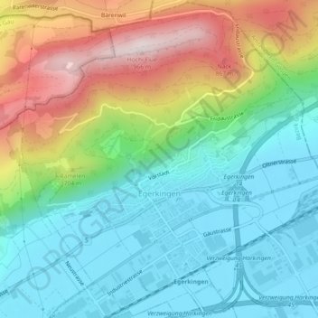
Egerkingen topographic map
Interactive map
Click on the map to display elevation.
About this map
Name: Egerkingen topographic map, elevation, terrain.
Location: Egerkingen, Bezirk Gäu, Amtei Thal-Gäu, Solothurn, 4622, Schweiz (47.31075 7.77483 47.34072 7.81948)
Average elevation: 595 m
Minimum elevation: 428 m
Maximum elevation: 934 m
Other topographic maps
Click on a map to view its topography, its elevation and its terrain.
Welschenrohr-Gänsbrunnen
Schweiz > Solothurn > Amtei Thal-Gäu
Welschenrohr-Gänsbrunnen, Bezirk Thal, Amtei Thal-Gäu, Solothurn, 4716, Schweiz
Average elevation: 823 m