
Thank you for supporting this site ❤️
Make a donation
Make a donation
Fouts Springs topographic map
Click on the map to display elevation.
Thank you for supporting this site ❤️
Make a donation
Make a donation
About this map
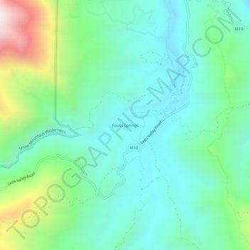
Name: Fouts Springs topographic map, elevation, terrain.
Location: Fouts Springs, Colusa County, California, United States (39.33322 -122.68499 39.37322 -122.64499)
Average elevation: 696 m
Minimum elevation: 460 m
Maximum elevation: 1,399 m
Thank you for supporting this site ❤️
Make a donation
Make a donation
Other topographic maps
Click on a map to view its topography, its elevation and its terrain.