
Make a donation
Vex topographic map
Click on the map to display elevation.
Make a donation
About this map
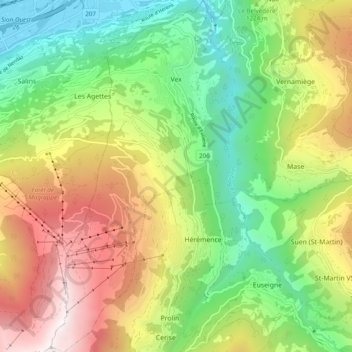
Name: Vex topographic map, elevation, terrain.
Location: Vex, Hérens, Wallis, 2305, Switzerland (46.15915 7.36385 46.22645 7.41523)
Average elevation: 1,285 m
Minimum elevation: 482 m
Maximum elevation: 2,448 m
Make a donation
Other topographic maps
Click on a map to view its topography, its elevation and its terrain.
Mase
Switzerland > Wallis > Hérens > Mont-Noble
The village is located in the Hérens district on the right bank of the Borgne and the left bank of the Rhone in the Val d'Hérens at an elevation of 1,345 m (4,413 ft). It consists of the village of Mase.
Average elevation: 1,272 m
Make a donation
Make a donation
Make a donation