
Thank you for supporting this site ❤️
Make a donation
Make a donation
Phillips topographic map
Click on the map to display elevation.
Thank you for supporting this site ❤️
Make a donation
Make a donation
About this map
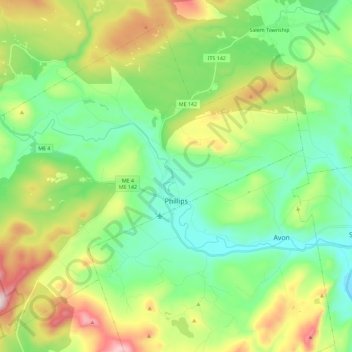
Name: Phillips topographic map, elevation, terrain.
Location: Phillips, Franklin County, Maine, 04966, United States (44.76446 -70.48527 44.90439 -70.25748)
Average elevation: 322 m
Minimum elevation: 124 m
Maximum elevation: 747 m
Thank you for supporting this site ❤️
Make a donation
Make a donation
Other topographic maps
Click on a map to view its topography, its elevation and its terrain.
Thank you for supporting this site ❤️
Make a donation
Make a donation
Sandy River Plantation
United States > Maine > Franklin County > Sandy River Plantation
Average elevation: 589 m
Height of Land Scenic Overlook
United States > Maine > Franklin County > Township D > Rangeley Plantation
Average elevation: 601 m
Thank you for supporting this site ❤️
Make a donation
Make a donation