
Thank you for supporting this site ❤️
Make a donation
Make a donation
Chez Durand topographic map
Click on the map to display elevation.
Thank you for supporting this site ❤️
Make a donation
Make a donation
About this map
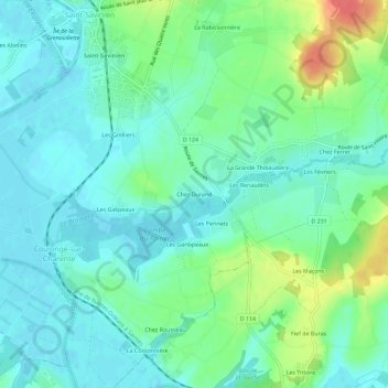
Name: Chez Durand topographic map, elevation, terrain.
Average elevation: 16 m
Minimum elevation: -1 m
Maximum elevation: 57 m
Thank you for supporting this site ❤️
Make a donation
Make a donation
Other topographic maps
Click on a map to view its topography, its elevation and its terrain.
Saint-Savinien
France > Nouvelle-Aquitaine > Charente-Maritime > Saint-Savinien
Average elevation: 28 m