
Thank you for supporting this site ❤️
Make a donation
Make a donation
North Bend topographic map
Click on the map to display elevation.
Thank you for supporting this site ❤️
Make a donation
Make a donation
About this map
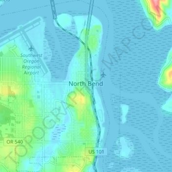
Name: North Bend topographic map, elevation, terrain.
Location: North Bend, Coos County, Oregon, United States (43.38389 -124.25952 43.42779 -124.21596)
Average elevation: 11 m
Minimum elevation: -6 m
Maximum elevation: 105 m
Thank you for supporting this site ❤️
Make a donation
Make a donation
Other topographic maps
Click on a map to view its topography, its elevation and its terrain.
Thank you for supporting this site ❤️
Make a donation
Make a donation
Thank you for supporting this site ❤️
Make a donation
Make a donation