
Make a donation
Ansley Common topographic map
Click on the map to display elevation.
Make a donation
About this map
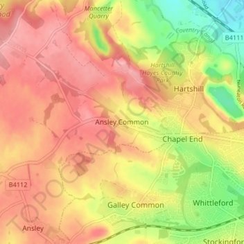
Name: Ansley Common topographic map, elevation, terrain.
Average elevation: 138 m
Minimum elevation: 73 m
Maximum elevation: 178 m
Make a donation
Other topographic maps
Click on a map to view its topography, its elevation and its terrain.
Make a donation
Hartshill Hayes Country Park
United Kingdom > England > Warwickshire > North Warwickshire > Ansley Common
Average elevation: 127 m
Merevale Lake
United Kingdom > England > Warwickshire > North Warwickshire > Atherstone
Average elevation: 119 m
Make a donation
Make a donation
Holbech's Wood
United Kingdom > England > Warwickshire > North Warwickshire > Fillongley CP
Average elevation: 140 m
Hoar Park
United Kingdom > England > Warwickshire > North Warwickshire > Bentley CP
Average elevation: 135 m
Make a donation
Pooley Country Park
United Kingdom > England > Warwickshire > North Warwickshire > Polesworth
Average elevation: 76 m
Lea Marston Purification Lakes
United Kingdom > England > Warwickshire > North Warwickshire > Marston
Average elevation: 70 m
Make a donation
Make a donation
Make a donation