
Thank you for supporting this site ❤️
Make a donation
Make a donation
Nahanni Butte topographic map
Click on the map to display elevation.
Thank you for supporting this site ❤️
Make a donation
Make a donation
About this map
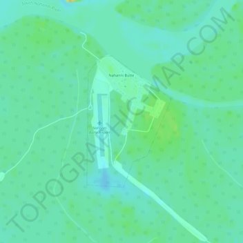
Name: Nahanni Butte topographic map, elevation, terrain.
Average elevation: 182 m
Minimum elevation: 174 m
Maximum elevation: 201 m
Thank you for supporting this site ❤️
Make a donation
Make a donation
Other topographic maps
Click on a map to view its topography, its elevation and its terrain.
Thank you for supporting this site ❤️
Make a donation
Make a donation
Jean Marie River
Canada > Northwest Territories > Dehcho Region > Jean Marie River
Average elevation: 142 m
Thank you for supporting this site ❤️
Make a donation
Make a donation
Thank you for supporting this site ❤️
Make a donation
Make a donation