
Thank you for supporting this site ❤️
Make a donation
Make a donation
Batang Rajang topographic map
Click on the map to display elevation.
Thank you for supporting this site ❤️
Make a donation
Make a donation
About this map
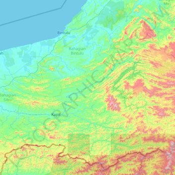
Name: Batang Rajang topographic map, elevation, terrain.
Location: Batang Rajang, Belaga, Kapit Division, Sarawak, Malaysia (2.00658 111.54304 2.78944 114.05487)
Average elevation: 307 m
Minimum elevation: 0 m
Maximum elevation: 1,957 m
Thank you for supporting this site ❤️
Make a donation
Make a donation
Other topographic maps
Click on a map to view its topography, its elevation and its terrain.