
Thank you for supporting this site ❤️
Make a donation
Make a donation
Ponui Island topographic map
Click on the map to display elevation.
Thank you for supporting this site ❤️
Make a donation
Make a donation
About this map
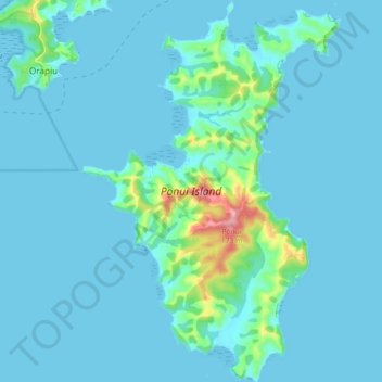
Name: Ponui Island topographic map, elevation, terrain.
Location: Ponui Island, Waiheke, Auckland, New Zealand (-36.90143 175.15262 -36.83007 175.21408)
Average elevation: 15 m
Minimum elevation: -1 m
Maximum elevation: 159 m
Thank you for supporting this site ❤️
Make a donation
Make a donation
Other topographic maps
Click on a map to view its topography, its elevation and its terrain.