
Thank you for supporting this site ❤️
Make a donation
Make a donation
Finkarby topographic map
Click on the map to display elevation.
Thank you for supporting this site ❤️
Make a donation
Make a donation
About this map
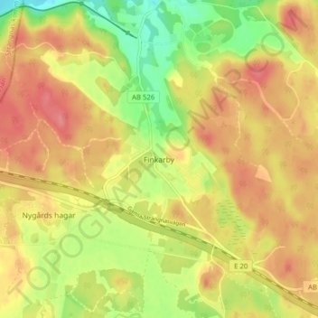
Name: Finkarby topographic map, elevation, terrain.
Location: Finkarby, Nykvarns kommun, Provinz Stockholm, 155 93, Schweden (59.20484 17.28824 59.24484 17.32824)
Average elevation: 42 m
Minimum elevation: 0 m
Maximum elevation: 71 m
Thank you for supporting this site ❤️
Make a donation
Make a donation
Other topographic maps
Click on a map to view its topography, its elevation and its terrain.
Thank you for supporting this site ❤️
Make a donation
Make a donation
Thank you for supporting this site ❤️
Make a donation
Make a donation
Stockholm
Stockholm baute auch seine Position als Kulturzentrum weiter aus und man bemühte sich, höhere Bildungseinrichtungen nach Stockholm zu bekommen. Im 19. Jahrhundert bekam Stockholm mehrere wissenschaftliche Institute, wie beispielsweise das Karolinische Institut und das Technologische Institut, das 1877 eine…
Average elevation: 25 m
Thank you for supporting this site ❤️
Make a donation
Make a donation