
Thank you for supporting this site ❤️
Make a donation
Make a donation
Buochs topographic map
Click on the map to display elevation.
Thank you for supporting this site ❤️
Make a donation
Make a donation
About this map
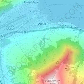
Name: Buochs topographic map, elevation, terrain.
Location: Buochs, Nidwalden, 6374, Switzerland (46.94495 8.38697 46.98401 8.45095)
Average elevation: 702 m
Minimum elevation: 431 m
Maximum elevation: 1,792 m
Thank you for supporting this site ❤️
Make a donation
Make a donation
Other topographic maps
Click on a map to view its topography, its elevation and its terrain.
ewl Ausgleichsbecken Untertrübsee
Switzerland > Nidwalden > Wolfenschiessen
Average elevation: 1,458 m
Bürgenstock
Switzerland > Nidwalden > Ennetbürgen
On the Dufourkarte (Dufour Map), the topographic map of Switzerland from 1844 to 1864, the mountain ridge as a whole had no name. The highest crest was referred to as Hametschwand.
Average elevation: 641 m
Thank you for supporting this site ❤️
Make a donation
Make a donation