
Rüdesheim am Rhein topographic map
Click on the map to display elevation.
About this map
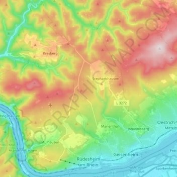
Name: Rüdesheim am Rhein topographic map, elevation, terrain.
Location: Rüdesheim am Rhein, Rheingau-Taunus-Kreis, Hesse, 65385, Germany (49.97184 7.83832 50.08597 7.94783)
Average elevation: 297 m
Minimum elevation: 73 m
Maximum elevation: 612 m
Other topographic maps
Click on a map to view its topography, its elevation and its terrain.
Wehener Wand und Rentmauer Wiesbaden
Germany > Hesse > Rheingau-Taunus-Kreis > Wiesbaden
Average elevation: 377 m