
Thank you for supporting this site ❤️
Make a donation
Make a donation
Schmithof topographic map
Click on the map to display elevation.
Thank you for supporting this site ❤️
Make a donation
Make a donation
Schmithof
Der Ort liegt knapp zwei Kilometer östlich der Staatsgrenze zu Belgien im Vennvorland zwischen Walheim und Sief auf einer Höhe bis zu 300 m ü. NN. Südlich fällt das Gelände zum Tal der Inde ab und steigt dann zu der Nordeifel hin an.
Thank you for supporting this site ❤️
Make a donation
Make a donation
About this map
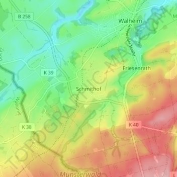
Name: Schmithof topographic map, elevation, terrain.
Average elevation: 302 m
Minimum elevation: 243 m
Maximum elevation: 378 m
Thank you for supporting this site ❤️
Make a donation
Make a donation