
Thank you for supporting this site ❤️
Make a donation
Make a donation
Port Townsend topographic map
Click on the map to display elevation.
Thank you for supporting this site ❤️
Make a donation
Make a donation
About this map
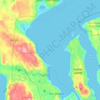
Name: Port Townsend topographic map, elevation, terrain.
Location: Port Townsend, Jefferson County, Washington, United States (48.02610 -122.79604 48.11819 -122.69386)
Average elevation: 31 m
Minimum elevation: -4 m
Maximum elevation: 126 m
Thank you for supporting this site ❤️
Make a donation
Make a donation
Other topographic maps
Click on a map to view its topography, its elevation and its terrain.
Port Townsend
United States > Washington > Jefferson County > Port Townsend > Port Townsend
Average elevation: 18 m