
Thank you for supporting this site ❤️
Make a donation
Make a donation
Oostkerke topographic map
Click on the map to display elevation.
Thank you for supporting this site ❤️
Make a donation
Make a donation
About this map
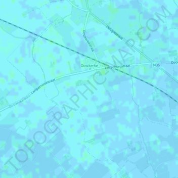
Name: Oostkerke topographic map, elevation, terrain.
Location: Oostkerke, Diksmuide, West-Vlaanderen, België (51.03079 2.78210 51.05597 2.81657)
Average elevation: 1 m
Minimum elevation: -2 m
Maximum elevation: 4 m
Thank you for supporting this site ❤️
Make a donation
Make a donation
Other topographic maps
Click on a map to view its topography, its elevation and its terrain.