
Thank you for supporting this site ❤️
Make a donation
Make a donation
Vibbard topographic map
Click on the map to display elevation.
Thank you for supporting this site ❤️
Make a donation
Make a donation
About this map
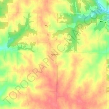
Name: Vibbard topographic map, elevation, terrain.
Location: Vibbard, Ray County, Missouri, United States (39.36056 -94.16633 39.40056 -94.12633)
Average elevation: 308 m
Minimum elevation: 265 m
Maximum elevation: 334 m
Thank you for supporting this site ❤️
Make a donation
Make a donation
Other topographic maps
Click on a map to view its topography, its elevation and its terrain.