
Make a donation
Wutachschlucht topographic map
Click on the map to display elevation.
Make a donation
About this map
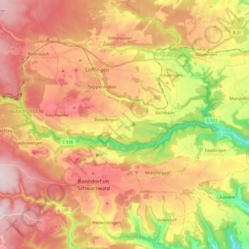
Name: Wutachschlucht topographic map, elevation, terrain.
Average elevation: 792 m
Minimum elevation: 534 m
Maximum elevation: 997 m
Make a donation
Other topographic maps
Click on a map to view its topography, its elevation and its terrain.
Glashütte
Deutschland > Baden-Württemberg > Landkreis Waldshut > Bonndorf im Schwarzwald
Average elevation: 953 m
Vogtsberg
Deutschland > Baden-Württemberg > Landkreis Waldshut > Bonndorf im Schwarzwald > Gündelwangen
Average elevation: 835 m
Wittlekofen
Deutschland > Baden-Württemberg > Landkreis Waldshut > Bonndorf im Schwarzwald
Wittlekofen liegt auf einer Anhöhe zwischen dem Steinatal und dem Ehrenbachtal.
Average elevation: 771 m
Tiefental
Deutschland > Baden-Württemberg > Landkreis Waldshut > Bonndorf im Schwarzwald
Average elevation: 810 m
Make a donation
Gündelwangen
Deutschland > Baden-Württemberg > Landkreis Waldshut > Bonndorf im Schwarzwald
Average elevation: 839 m
Brunnadern
Deutschland > Baden-Württemberg > Landkreis Waldshut > Bonndorf im Schwarzwald > Brunnadern
Average elevation: 754 m
Dillendorf
Deutschland > Baden-Württemberg > Landkreis Waldshut > Bonndorf im Schwarzwald
Average elevation: 741 m