
Make a donation
Guadeloupe topographic map
Click on the map to display elevation.
Make a donation
Guadeloupe
The two main islands are Basse-Terre (west) and Grande-Terre (east), which form a butterfly shape as viewed from above, the two 'wings' of which are separated by the Grand Cul-de-Sac Marin [ceb; fr; nl; sv], Rivière Salée [fr] and Petit Cul-de-Sac Marin [ceb; fr]. More than half of Guadeloupe's land surface consists of the 847.8 km2 Basse-Terre. The island is mountainous, containing such peaks as Mount Sans Toucher (4,442 feet; 1,354 metres) and Grande Découverte (4,143 feet; 1,263 metres), culminating in the active volcano La Grande Soufrière, the highest mountain peak in the Lesser Antilles with an elevation of 1,467 metres (4,813 ft). In contrast Grande-Terre is mostly flat, with rocky coasts to the north, irregular hills at the centre, mangrove at the southwest, and white sand beaches sheltered by coral reefs along the southern shore. This is where the main tourist resorts are found.
Make a donation
About this map
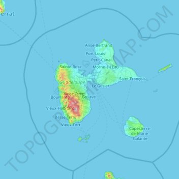
Name: Guadeloupe topographic map, elevation, terrain.
Location: Guadeloupe, France (15.64441 -62.01804 16.71400 -60.79197)
Average elevation: 18 m
Minimum elevation: -1 m
Maximum elevation: 1,428 m
Make a donation
Other topographic maps
Click on a map to view its topography, its elevation and its terrain.
La Bachellerie-du-Nord
France > Nouvelle-Aquitaine > Haute-Vienne > Saint-Yrieix-la-Perche
Average elevation: 386 m
Make a donation
Make a donation
Make a donation
Col du Galibier
France > Provence-Alpes-Côte d'Azur > Hautes-Alpes > Le Monêtier-les-Bains
Before 1976, the tunnel was the only point of passage at the top, at an altitude of 2556 m. The tunnel was closed for restoration until 2002, and a new road was constructed over the summit. The re-opened tunnel is a single lane controlled by traffic lights, which are among the highest such installations in…
Average elevation: 2,491 m
Plan d'eau privé
France > Pays de la Loire > Loire-Atlantique > Prinquiau > Clas
Average elevation: 54 m
Make a donation
Pyrenees
The Pyrenees (/ˈpɪrɪniːz/; Spanish: Pirineos [piɾiˈneos]; French: Pyrénées [piʁene] (listen); Catalan: Pirineu [piɾiˈnɛw]; Basque: Pirinioak [piɾini.o.ak]; Occitan: Pirenèus [piɾeˈnɛws]; Aragonese: Pirineus) is a mountain range straddling the border of France and Spain. It extends nearly 500…
Average elevation: 484 m
Eget Village
France > Occitania > Hautes Pyrenees > Aragnouet > Eget Village
Average elevation: 1,560 m
Make a donation
Le Planet
France > Auvergne-Rhône-Alpes > Upper Savoy > Chamonix-Mont-Blanc > Le Planet
Average elevation: 1,672 m
Make a donation
Les Chaussendents
France > Provence-Alpes-Côte d'Azur > Hautes-Alpes > La Chapelle-en-Valgaudémar > Les Chaussendents
Average elevation: 1,619 m