
洛阳市 topographic map
Interactive map
Click on the map to display elevation.
About this map
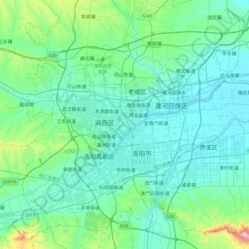
Name: 洛阳市 topographic map, elevation, terrain.
Location: 洛阳市, 河南省, 471026, 中国 (34.45965 112.28770 34.77965 112.60770)
Average elevation: 223 m
Minimum elevation: 114 m
Maximum elevation: 908 m
洛阳三面环山,有两条大河穿过。洛阳市地处九州腹地,位于中国第二阶梯与第三阶梯交界带,欧亚大陆桥东段,在东经111°8' - 112°59'、北纬33°35' - 35°05'之间,东西长约179公里,南北宽约168公里。横跨黄河中游南北两岸,东邻郑州,西接三门峡,北跨黄河与焦作接壤,南与平顶山、南阳相连。地势西高东低,境内山川丘陵交错,地形复杂多样,其中山区面积占45.51%,丘陵面积占40.73%,平原面积占13.8%。
Other topographic maps
Click on a map to view its topography, its elevation and its terrain.