
Thank you for supporting this site ❤️
Make a donation
Make a donation
Gabriels topographic map
Click on the map to display elevation.
Thank you for supporting this site ❤️
Make a donation
Make a donation
About this map
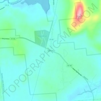
Name: Gabriels topographic map, elevation, terrain.
Average elevation: 530 m
Minimum elevation: 498 m
Maximum elevation: 666 m
Thank you for supporting this site ❤️
Make a donation
Make a donation
Other topographic maps
Click on a map to view its topography, its elevation and its terrain.
Village of Saranac Lake
United States > New York > Franklin County > Town of Harrietstown
Average elevation: 502 m
Thank you for supporting this site ❤️
Make a donation
Make a donation
Thank you for supporting this site ❤️
Make a donation
Make a donation
Thank you for supporting this site ❤️
Make a donation
Make a donation
Fish Creek Pond
United States > New York > Franklin County > Town of Santa Clara
Average elevation: 491 m
Thank you for supporting this site ❤️
Make a donation
Make a donation
Village of Saranac Lake
United States > New York > Franklin County > Town of Harrietstown
Average elevation: 502 m
Thank you for supporting this site ❤️
Make a donation
Make a donation
Fish Creek Pond Campground
United States > New York > Franklin County > Town of Santa Clara
Average elevation: 488 m
Town of Chateaugay
United States > New York > Franklin County > Town of Chateaugay
Average elevation: 280 m
Thank you for supporting this site ❤️
Make a donation
Make a donation