
Thank you for supporting this site ❤️
Make a donation
Make a donation
Hottorf topographic map
Click on the map to display elevation.
Thank you for supporting this site ❤️
Make a donation
Make a donation
About this map
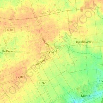
Name: Hottorf topographic map, elevation, terrain.
Location: Hottorf, Linnich, Kreis Düren, Nordrhein-Westfalen, Deutschland (50.98037 6.32630 51.02037 6.36630)
Average elevation: 101 m
Minimum elevation: 81 m
Maximum elevation: 109 m
Thank you for supporting this site ❤️
Make a donation
Make a donation
Other topographic maps
Click on a map to view its topography, its elevation and its terrain.