
Thank you for supporting this site ❤️
Make a donation
Make a donation
Forest Hills topographic map
Click on the map to display elevation.
Thank you for supporting this site ❤️
Make a donation
Make a donation
About this map
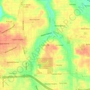
Name: Forest Hills topographic map, elevation, terrain.
Average elevation: 85 m
Minimum elevation: 55 m
Maximum elevation: 101 m
Thank you for supporting this site ❤️
Make a donation
Make a donation
Other topographic maps
Click on a map to view its topography, its elevation and its terrain.
Woodmere Park
United States > Alabama > Montgomery County > Montgomery > Bellwood Plantation
Average elevation: 84 m