
Thank you for supporting this site ❤️
Make a donation
Make a donation
Black Head topographic map
Click on the map to display elevation.
Thank you for supporting this site ❤️
Make a donation
Make a donation
About this map
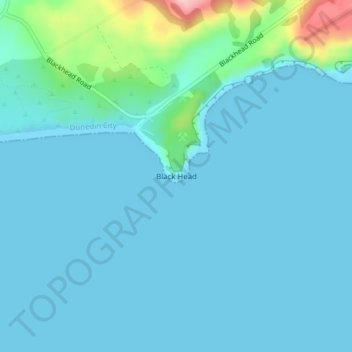
Name: Black Head topographic map, elevation, terrain.
Location: Black Head, Dunedin City, Otago, 9052, New Zealand (-45.93205 170.43193 -45.93195 170.43203)
Average elevation: 20 m
Minimum elevation: 0 m
Maximum elevation: 164 m
Thank you for supporting this site ❤️
Make a donation
Make a donation
Other topographic maps
Click on a map to view its topography, its elevation and its terrain.