
Thank you for supporting this site ❤️
Make a donation
Make a donation
Mountain Lake topographic map
Click on the map to display elevation.
Thank you for supporting this site ❤️
Make a donation
Make a donation
About this map
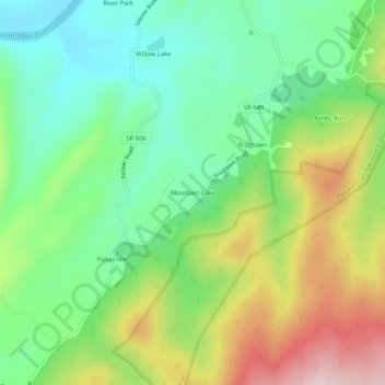
Name: Mountain Lake topographic map, elevation, terrain.
Location: Mountain Lake, Clarke County, Virginia, United States (39.04122 -77.96166 39.08122 -77.92166)
Average elevation: 261 m
Minimum elevation: 113 m
Maximum elevation: 513 m
Thank you for supporting this site ❤️
Make a donation
Make a donation
Other topographic maps
Click on a map to view its topography, its elevation and its terrain.
University of Virginia Blandy Experimental Farm and Virginia State Arboretum
United States > Virginia > Clarke County > Boyce > Greenway Estates
Average elevation: 181 m