
Make a donation
Denmark topographic map
Click on the map to display elevation.
Make a donation
About this map
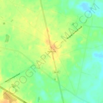
Name: Denmark topographic map, elevation, terrain.
Location: Denmark, Bulloch County, Georgia, United States (32.26463 -81.74400 32.30463 -81.70400)
Average elevation: 45 m
Minimum elevation: 29 m
Maximum elevation: 60 m
Make a donation
Other topographic maps
Click on a map to view its topography, its elevation and its terrain.
Statesboro
United States > Georgia > Bulloch County
According to the United States Census Bureau, the city has a total area of 13.9 square miles (35.9 km2), of which 13.5 square miles (35.0 km2) is land and 0.35 square miles (0.9 km2), or 2.60%, is water. The city is in the coastal plain region, or Low Country, of Georgia, so it is mainly flat with a few small…
Average elevation: 64 m
Make a donation
Statesboro
United States > Georgia > Bulloch County
According to the United States Census Bureau, the city has a total area of 13.9 square miles (35.9 km2), of which 13.5 square miles (35.0 km2) is land and 0.35 square miles (0.9 km2), or 2.60%, is water. The city is in the coastal plain region, or Low Country, of Georgia, so it is mainly flat with a few small…
Average elevation: 64 m