
Thank you for supporting this site ❤️
Make a donation
Make a donation
Queen Elizabeth Country Park topographic map
Click on the map to display elevation.
Thank you for supporting this site ❤️
Make a donation
Make a donation
About this map
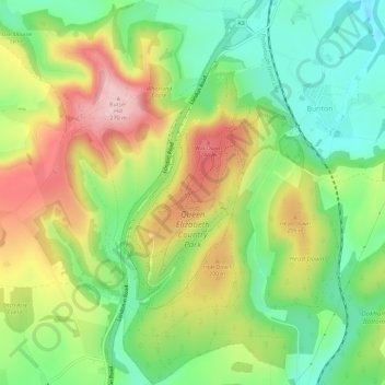
Name: Queen Elizabeth Country Park topographic map, elevation, terrain.
Average elevation: 151 m
Minimum elevation: 61 m
Maximum elevation: 269 m
Thank you for supporting this site ❤️
Make a donation
Make a donation
Other topographic maps
Click on a map to view its topography, its elevation and its terrain.
Ditcham Woods.
United Kingdom > England > Hampshire > East Hampshire > Buriton
Average elevation: 136 m