
Make a donation
Wemmetsweiler topographic map
Click on the map to display elevation.
Make a donation
About this map
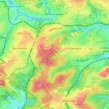
Name: Wemmetsweiler topographic map, elevation, terrain.
Average elevation: 322 m
Minimum elevation: 254 m
Maximum elevation: 413 m
Make a donation
Other topographic maps
Click on a map to view its topography, its elevation and its terrain.
Landsweiler-Reden
Deutschland > Saarland > Landkreis Neunkirchen > Schiffweiler
Average elevation: 304 m
Heiligenwald
Deutschland > Saarland > Landkreis Neunkirchen > Schiffweiler
In Schiffweiler wurde 2014 ein Windpark errichtet. Der Park besteht aus fünf identischen Windkraftanlagen des Typs Vensys112. Die Nabenhöhe der Anlagen beträgt 140 Meter, der Rotordurchmesser beträgt 112 Meter, was einer Rotorkreisfläche von ca. 1 ha und einer Gesamthöhe von ca. 196 Meter entspricht. Die…
Average elevation: 322 m
Make a donation
Stennweiler
Deutschland > Saarland > Landkreis Neunkirchen > Schiffweiler > Stennweiler
Average elevation: 342 m