
Thank you for supporting this site ❤️
Make a donation
Make a donation
Winkeln topographic map
Click on the map to display elevation.
Thank you for supporting this site ❤️
Make a donation
Make a donation
About this map
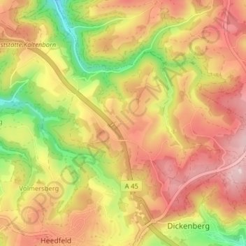
Name: Winkeln topographic map, elevation, terrain.
Average elevation: 397 m
Minimum elevation: 249 m
Maximum elevation: 509 m
Thank you for supporting this site ❤️
Make a donation
Make a donation
Other topographic maps
Click on a map to view its topography, its elevation and its terrain.
Rölvedermühle
Deutschland > Nordrhein-Westfalen > Märkischer Kreis > Schalksmühle > Everinghausen
Average elevation: 358 m
58579
Deutschland > Nordrhein-Westfalen > Märkischer Kreis > Schalksmühle > Harrenscheid > Davidshöhe
Average elevation: 350 m