
Thank you for supporting this site ❤️
Make a donation
Make a donation
Pecan Grove topographic map
Click on the map to display elevation.
Thank you for supporting this site ❤️
Make a donation
Make a donation
About this map
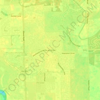
Name: Pecan Grove topographic map, elevation, terrain.
Location: Pecan Grove, Fort Bend County, Texas, 77496, United States (29.60607 -95.75162 29.64607 -95.71162)
Average elevation: 27 m
Minimum elevation: 10 m
Maximum elevation: 30 m
Thank you for supporting this site ❤️
Make a donation
Make a donation
Other topographic maps
Click on a map to view its topography, its elevation and its terrain.
Sienna (Brazos River) Park
United States > Texas > Fort Bend County > Missouri City
Average elevation: 20 m