
Thank you for supporting this site ❤️
Make a donation
Make a donation
Gol topographic map
Click on the map to display elevation.
Thank you for supporting this site ❤️
Make a donation
Make a donation
About this map
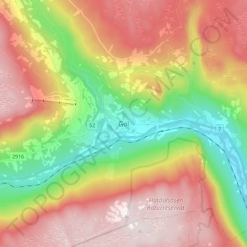
Name: Gol topographic map, elevation, terrain.
Location: Gol, Buskerud, Norway (60.66143 8.90551 60.74143 8.98551)
Average elevation: 581 m
Minimum elevation: 185 m
Maximum elevation: 979 m
Thank you for supporting this site ❤️
Make a donation
Make a donation
Other topographic maps
Click on a map to view its topography, its elevation and its terrain.