
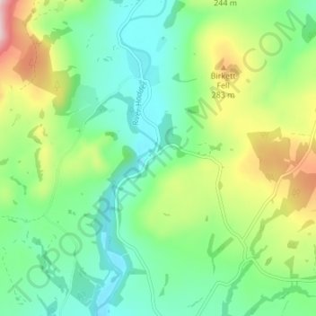
Whitewell topographic map
Interactive map
Click on the map to display elevation.
About this map
Name: Whitewell topographic map, elevation, terrain.
Average elevation: 184 m
Minimum elevation: 92 m
Maximum elevation: 383 m
Other topographic maps
Click on a map to view its topography, its elevation and its terrain.
Salesbury
Verenigd Koninkrijk > Engeland > Lancashire > Ribble Valley
Salesbury, Ribble Valley, Lancashire, Engeland, Verenigd Koninkrijk
Average elevation: 77 m
Chipping
Verenigd Koninkrijk > Engeland > Lancashire > Ribble Valley
Chipping, Ribble Valley, Lancashire, Engeland, Verenigd Koninkrijk
Average elevation: 194 m
Thornley-with-Wheatley
Verenigd Koninkrijk > Engeland > Lancashire > Ribble Valley
Thornley-with-Wheatley, Ribble Valley, Lancashire, Engeland, Verenigd Koninkrijk
Average elevation: 150 m