
Thank you for supporting this site ❤️
Make a donation
Make a donation
Waigolshausen topographic map
Click on the map to display elevation.
Thank you for supporting this site ❤️
Make a donation
Make a donation
About this map
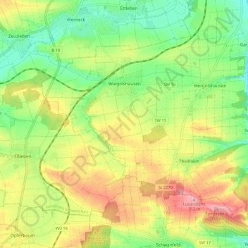
Name: Waigolshausen topographic map, elevation, terrain.
Location: Waigolshausen, Landkreis Schweinfurt, Bavaria, 97534, Germany (49.92939 10.08574 49.97737 10.18973)
Average elevation: 254 m
Minimum elevation: 203 m
Maximum elevation: 317 m
Thank you for supporting this site ❤️
Make a donation
Make a donation
Other topographic maps
Click on a map to view its topography, its elevation and its terrain.