
Make a donation
Engstingen topographic map
Click on the map to display elevation.
Make a donation
Engstingen
Engstingen liegt am Nordrand der Schwäbischen Alb im Bereich der Mittleren Kuppenalb, in 680 bis 750 Meter Höhe auf der Albhochfläche oberhalb des Albtraufs. Es liegt im Tal der Ur-Lauter, etwa 15 km Luftlinie südlich der Kreisstadt Reutlingen.
Make a donation
About this map
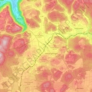
Name: Engstingen topographic map, elevation, terrain.
Average elevation: 735 m
Minimum elevation: 512 m
Maximum elevation: 858 m
Make a donation
Other topographic maps
Click on a map to view its topography, its elevation and its terrain.
Gönningen
Deutschland > Baden-Württemberg > Landkreis Reutlingen > Reutlingen
Average elevation: 608 m
Oberwilzingen
Deutschland > Baden-Württemberg > Landkreis Reutlingen > Hayingen
Average elevation: 637 m
Bronnweiler
Deutschland > Baden-Württemberg > Landkreis Reutlingen > Reutlingen
Average elevation: 520 m
Make a donation
Böhringen
Deutschland > Baden-Württemberg > Landkreis Reutlingen > Römerstein
Average elevation: 775 m