
Thank you for supporting this site ❤️
Make a donation
Make a donation
Goose Corner topographic map
Click on the map to display elevation.
Thank you for supporting this site ❤️
Make a donation
Make a donation
About this map
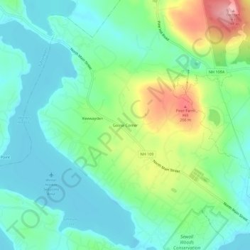
Name: Goose Corner topographic map, elevation, terrain.
Average elevation: 189 m
Minimum elevation: 149 m
Maximum elevation: 286 m
Thank you for supporting this site ❤️
Make a donation
Make a donation
Other topographic maps
Click on a map to view its topography, its elevation and its terrain.
Bill Rae Conservation Area
United States > New Hampshire > Carroll County > Wolfeboro > Stockbridge Corner
Average elevation: 244 m