
Thank you for supporting this site ❤️
Make a donation
Make a donation
Lochbuie topographic map
Click on the map to display elevation.
Thank you for supporting this site ❤️
Make a donation
Make a donation
About this map
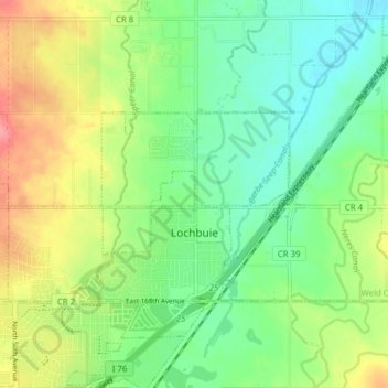
Name: Lochbuie topographic map, elevation, terrain.
Location: Lochbuie, Weld County, Colorado, United States (39.99535 -104.75392 40.03933 -104.67592)
Average elevation: 1,538 m
Minimum elevation: 1,508 m
Maximum elevation: 1,587 m
Thank you for supporting this site ❤️
Make a donation
Make a donation
Other topographic maps
Click on a map to view its topography, its elevation and its terrain.
Thank you for supporting this site ❤️
Make a donation
Make a donation
Thank you for supporting this site ❤️
Make a donation
Make a donation
Greeley
United States > Colorado > Weld County > Greeley > Greeley
Greeley experiences a semi-arid climate (Köppen BSk). High temperatures are generally around 90–95 °F (32 °C) in the summer and 40-45 °F (4 °C) in the winter, although significant variation occurs. The hottest days generally occur around the third week of July and the coldest in January. Nighttime lows…
Average elevation: 1,458 m