
Thank you for supporting this site ❤️
Make a donation
Make a donation
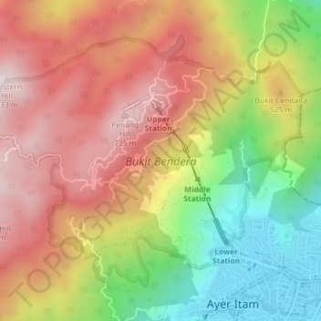
Penang Hill topographic map
Click on the map to display elevation.
Thank you for supporting this site ❤️
Make a donation
Make a donation
Penang Hill
A number of hills are covered by Penang Hill, with the highest point being Western Hill that stands at an altitude of 833 meters (2,733 feet) above sea level. Penang Hill is a hilly and forested area that stands out from the lowlands of Malaysia by being hilly and wooded. The area was used as a retreat during the British colonial period, and is now a very popular tourist destination due to its history and heritage.
Thank you for supporting this site ❤️
Make a donation
Make a donation
About this map
Name: Penang Hill topographic map, elevation, terrain.
Average elevation: 436 m
Minimum elevation: 16 m
Maximum elevation: 804 m
Thank you for supporting this site ❤️
Make a donation
Make a donation