
Thank you for supporting this site ❤️
Make a donation
Make a donation
Eselsberg topographic map
Click on the map to display elevation.
Thank you for supporting this site ❤️
Make a donation
Make a donation
About this map
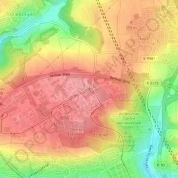
Name: Eselsberg topographic map, elevation, terrain.
Location: Eselsberg, Ulm, Baden-Württemberg, 89081, Deutschland (48.42545 9.95567 48.42555 9.95577)
Average elevation: 579 m
Minimum elevation: 505 m
Maximum elevation: 626 m
Thank you for supporting this site ❤️
Make a donation
Make a donation
Other topographic maps
Click on a map to view its topography, its elevation and its terrain.
Thank you for supporting this site ❤️
Make a donation
Make a donation
Thank you for supporting this site ❤️
Make a donation
Make a donation
Thank you for supporting this site ❤️
Make a donation
Make a donation