
Thank you for supporting this site ❤️
Make a donation
Make a donation
Lato island topographic map
Click on the map to display elevation.
Thank you for supporting this site ❤️
Make a donation
Make a donation
About this map
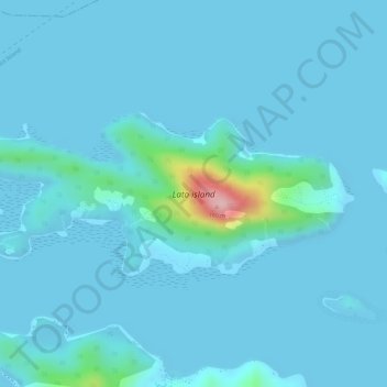
Name: Lato island topographic map, elevation, terrain.
Location: Lato island, Culion, Palawan, Mimaropa, 5315, Philippines (11.98424 119.93464 11.99591 119.96291)
Average elevation: 14 m
Minimum elevation: 0 m
Maximum elevation: 182 m
Thank you for supporting this site ❤️
Make a donation
Make a donation
Other topographic maps
Click on a map to view its topography, its elevation and its terrain.