
Penso topographic map
Interactive map
Click on the map to display elevation.
About this map
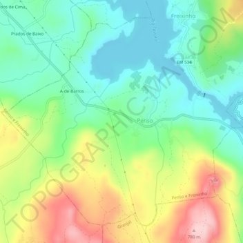
Name: Penso topographic map, elevation, terrain.
Location: Penso, Penso e Freixinho, Sernancelhe, Viseu, Portugal (40.90614 -7.56575 40.93745 -7.51739)
Average elevation: 626 m
Minimum elevation: 542 m
Maximum elevation: 772 m
Other topographic maps
Click on a map to view its topography, its elevation and its terrain.
A-de-Barros
Portugal > Viseu > Penso e Freixinho > Penso
A-de-Barros, Penso, Penso e Freixinho, Sernancelhe, Viseu, 3640-030, Portugal
Average elevation: 615 m