
Make a donation
Amsteg topographic map
Click on the map to display elevation.
Make a donation
About this map
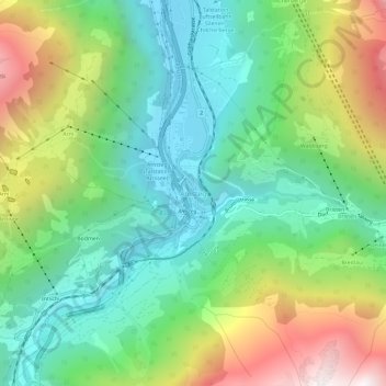
Name: Amsteg topographic map, elevation, terrain.
Location: Amsteg, Silenen, Uri, 6474, Switzerland (46.75108 8.65033 46.79108 8.69033)
Average elevation: 1,051 m
Minimum elevation: 491 m
Maximum elevation: 2,133 m
Make a donation
Other topographic maps
Click on a map to view its topography, its elevation and its terrain.
Andermatt
Switzerland > Uri > Korporation Ursern
Andermatt (Romansh: Ursera) is a mountain village and municipality in the canton of Uri in Switzerland. At an elevation of 1,437 meters (4,715 ft) above sea level, Andermatt is located at the center of the Saint-Gotthard Massif and the historical center cross of north-south and east-west traverses of…
Average elevation: 2,127 m
Make a donation
Make a donation
Make a donation
Altdorf (UR)
The municipality covers an area of 10.21 square kilometres (3.94 sq mi). The town proper sits at an altitude of 458 metres (1,503 ft) above sea level on a flat alluvial plain between the right bank of the river Reuss and the steep hillside of the Rossstock 2.4 km (1.5 mi) to the east. The scattered hamlets and…
Average elevation: 796 m