
Thank you for supporting this site ❤️
Make a donation
Make a donation
Paulatem topographic map
Click on the map to display elevation.
Thank you for supporting this site ❤️
Make a donation
Make a donation
Paulatem
Paulatem ligt in Zandlemig Vlaanderen en de hoogte bedraagt 17-50 meter. In het noorden stroomt de Munkbosbeek met natuurgebied Munkbosbeekvallei. In het zuiden stroomt de Zwalm met natuurgebied Zwalmvallei.
Thank you for supporting this site ❤️
Make a donation
Make a donation
About this map
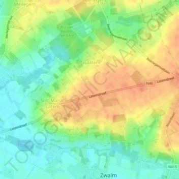
Name: Paulatem topographic map, elevation, terrain.
Location: Paulatem, Zwalm, Oudenaarde, Oost-Vlaanderen, België (50.88430 3.70736 50.90029 3.72946)
Average elevation: 31 m
Minimum elevation: 10 m
Maximum elevation: 52 m
Thank you for supporting this site ❤️
Make a donation
Make a donation
Other topographic maps
Click on a map to view its topography, its elevation and its terrain.