
Thank you for supporting this site ❤️
Make a donation
Make a donation
John Hart Dam topographic map
Click on the map to display elevation.
Thank you for supporting this site ❤️
Make a donation
Make a donation
About this map
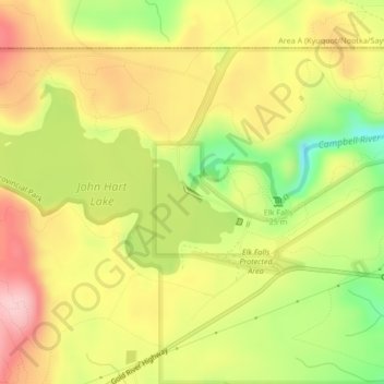
Name: John Hart Dam topographic map, elevation, terrain.
Average elevation: 155 m
Minimum elevation: 54 m
Maximum elevation: 239 m
Thank you for supporting this site ❤️
Make a donation
Make a donation
Other topographic maps
Click on a map to view its topography, its elevation and its terrain.
Elk Falls Viewing Platform
Canada > British Columbia > Strathcona Regional District > Campbell River
Average elevation: 137 m
Duncan Bay
Canada > British Columbia > Strathcona Regional District > Campbell River
Average elevation: 18 m
Elk Falls Provincial Park
Canada > British Columbia > Strathcona Regional District > Campbell River
Average elevation: 96 m
Duncan Bay
Canada > British Columbia > Strathcona Regional District > Campbell River
Average elevation: 19 m
Thank you for supporting this site ❤️
Make a donation
Make a donation
John Hart Lake
Canada > British Columbia > Strathcona Regional District > Campbell River
Average elevation: 161 m